Gaurav Chakrabarty
Repository of my web page
Gaurav Chakrabarty
Hi there! Welcome to my GitHub page.
I am Gaurav, and this page is a reflection of who I am, my ideas, works, and my constant learning.
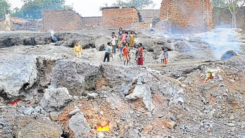
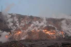
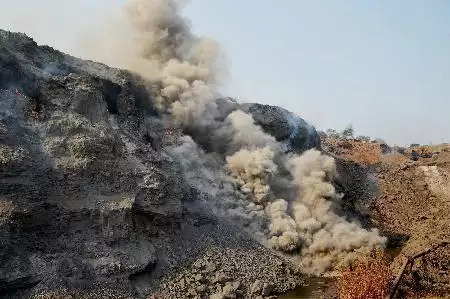
My journey began amid the smoldering heart of India’s coal belt—the Jharia Coal Field in Dhanbad—where I undertook my first project, detecting underground mine fire zones. With a foundation in IT and a deepening passion for geospatial science, I pursued post-graduation in Geoinformatics, a discipline that has since guided my professional path.
Over the years, I have woven technology with terrain, applying spatial insight to challenges in Land Use and Land Cover Mapping, Land Degradation Monitoring, Water Quality Assessment, and Urban Mapping.
I am deeply motivated to explore and apply artificial intelligence algorithms to enhance the precision and efficiency of geospatial analysis. More broadly, I aim to work on interdisciplinary projects that bring together science, technology, and human understanding to help answer complex, real-world questions.
This page is a quiet chronicle of that journey—a place where science meets storytelling, and maps trace not only the Earth, but a career shaped by curiosity and purpose. I invite you to explore, reflect, and perhaps, connect.
"In the language of terrain and technology, I found my voice."
Career Snapshot
-
Three years and 6 months of overall experience in Software Development, Geospatial Technology, Research and Training, Content Development, writing Technical Documents and Training Materials.
-
Knowledge of Data Analysis using Python and SQL
-
Knowledge of programming languages like C, C++, C#.NET, VB.NET, and RDBMS software like MS Access, Oracle, PostgreSQL, and MS-SQL Server.
-
Knowledge of GIS and Image processing software like ArcGIS, QGIS, and ERDAS Imagine.
-
Knowledge of WebGIS
-
Knowledge of programming in MATLAB in the domains of Statistics, Image Processing, and Machine Learning.
-
Good Communication and Presentation skills.
-
Good knowledge of Statistical Analysis.
-
Avid learner and inquisitive to update with new technological skill sets.
Alma Mater
M.Sc. in Geoinformatics
![]()
Department of Remote Sensing, BIT Mesra, Ranchi, Jharkhand, India.
PGDIP in Applied Geoinformatics
![]()
Computer-Aided Design Centre, Jadavpur University, Kolkata, West Bengal, India
M.Sc. in Information Technology
![]()
Vinoba Bhabe University, Hazaribagh, Jharkhand, India
![]()
ESIIL Data Short Course on Earth Data Science (July 2025-August 2025)
Analyzing vegetation cover changes in Chamarajanagar district between 2017 and 2021
In February 2019, massive forest fires broke out in several parts of Bandipur National Park, located in the Chamarajanagar district of Karnataka, India. The fire lasted for several days and destroyed vast stretches of forest, threatening biodiversity, wildlife habitats, and the ecological balance of the region. Forest fires of such scale not only result in immediate vegetation loss but also trigger long-term environmental impacts, including soil degradation, carbon emissions, and changes in land cover.
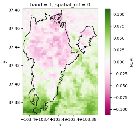
This project focuses on analyzing vegetation cover change in Chamarajanagar district between 2017 and 2021, with the specific objective of assessing the impact of the 2019 Bandipur forest fire.
NDVI Difference, Chamarajanagar District, Karnataka, India.
Tubarjal Valley, Saudi Arabia, Irrigation Project
- Project Setup
- Site Map OSM
- Data Wrangle
- Data Plotting
This project focused on observing and analyzing vegetation growth in the Tubarjal Valley region resulting from advancements in irrigation practices. The vegetation growth was analysed by comparing the NDVI changes in different periods ranging from [2001-2012] to [2013-2025]
NDVI Difference Mapping
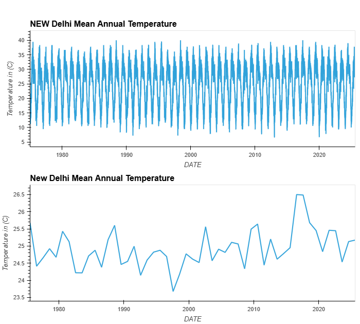
New Delhi Time Series
In this project, minimum, maximum, and average temperature data in degrees Celsius from 1975 to 2025 are analysed, and finally, the Mean and Maximum annual temperatures are plotted. Here is the plot of Annual Maximum Temperature
Interactive Maps
Interactive Map of Vinoba Bhave University, Hazaribagh, Jharkhand, India.
Interactive Map of Haskell Indian Nations University, Lawrence, Kansas.
Short Course
![]()
ESIIL Data Short Course on Earth Data Science (April 2024-May 2024)
Climate Code Challenge: Get started with open reproducible science! (API version)
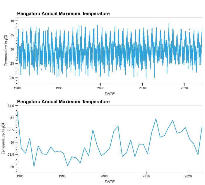
Bengaluru Time Series
In this project, minimum, maximum, and average temperature data in degrees Celsius from 1980 - 2023 were analyzed, and finally, the Mean and Maximum annual temperatures were plotted. Here is the plot of Annual Maximum Temperature
Vegetation Coding Challenge
Vegetation
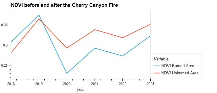
In this project, NDVI values are calculated and plotted for burned and unburned areas over the period from 2018 - 2023. The Study area for this assignment is Cherry Canyon, Colorado, USA.
Interactive Map of BIT Mesra
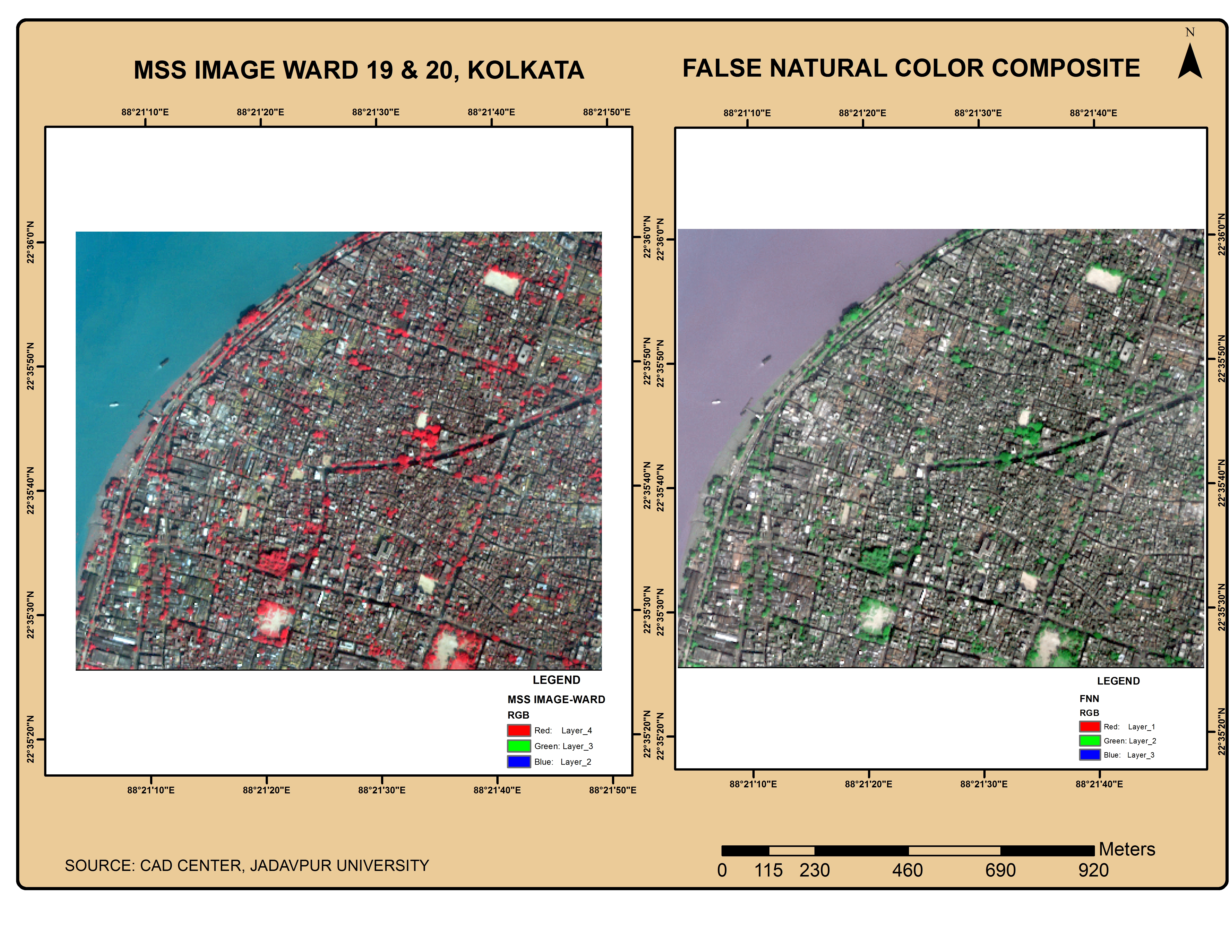
Feature Extraction and Classified Mapping in a specific Urban Area of KMC (Kolkata Municipal Corporation) using Geospatial techniques.
![]()
Computer-Aided Design Centre, Jadavpur University, Kolkata, West Bengal, India. (Aug 2018-Jan 2019)
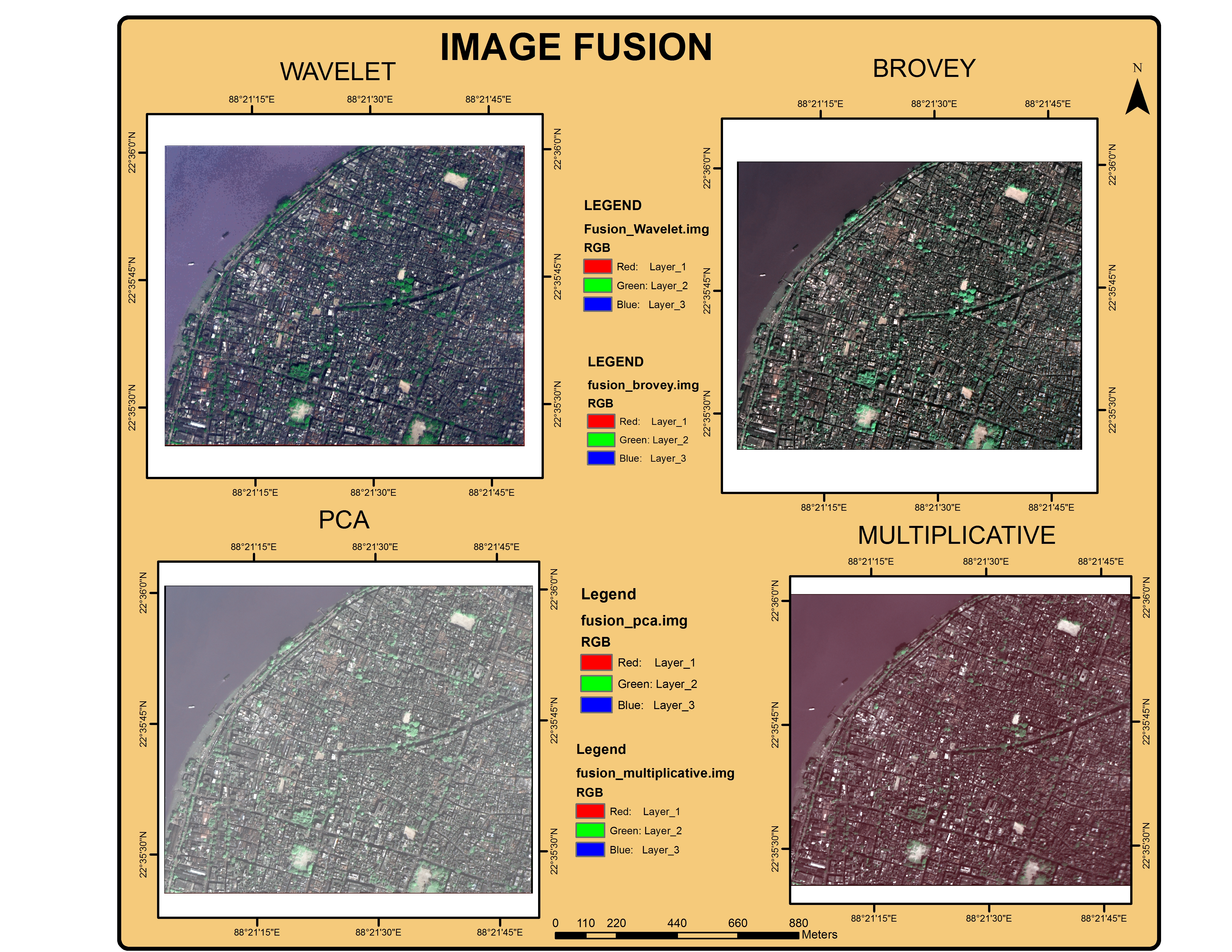
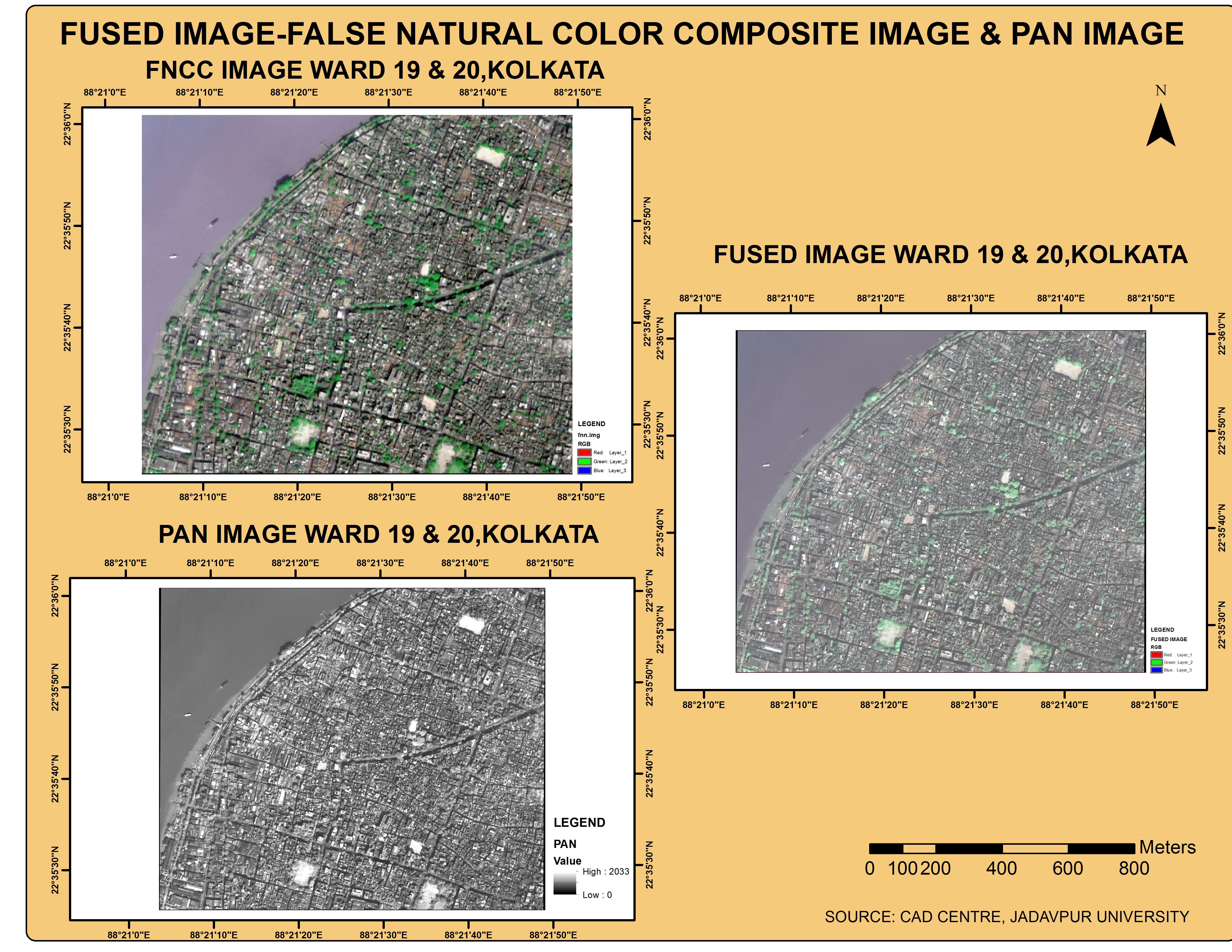
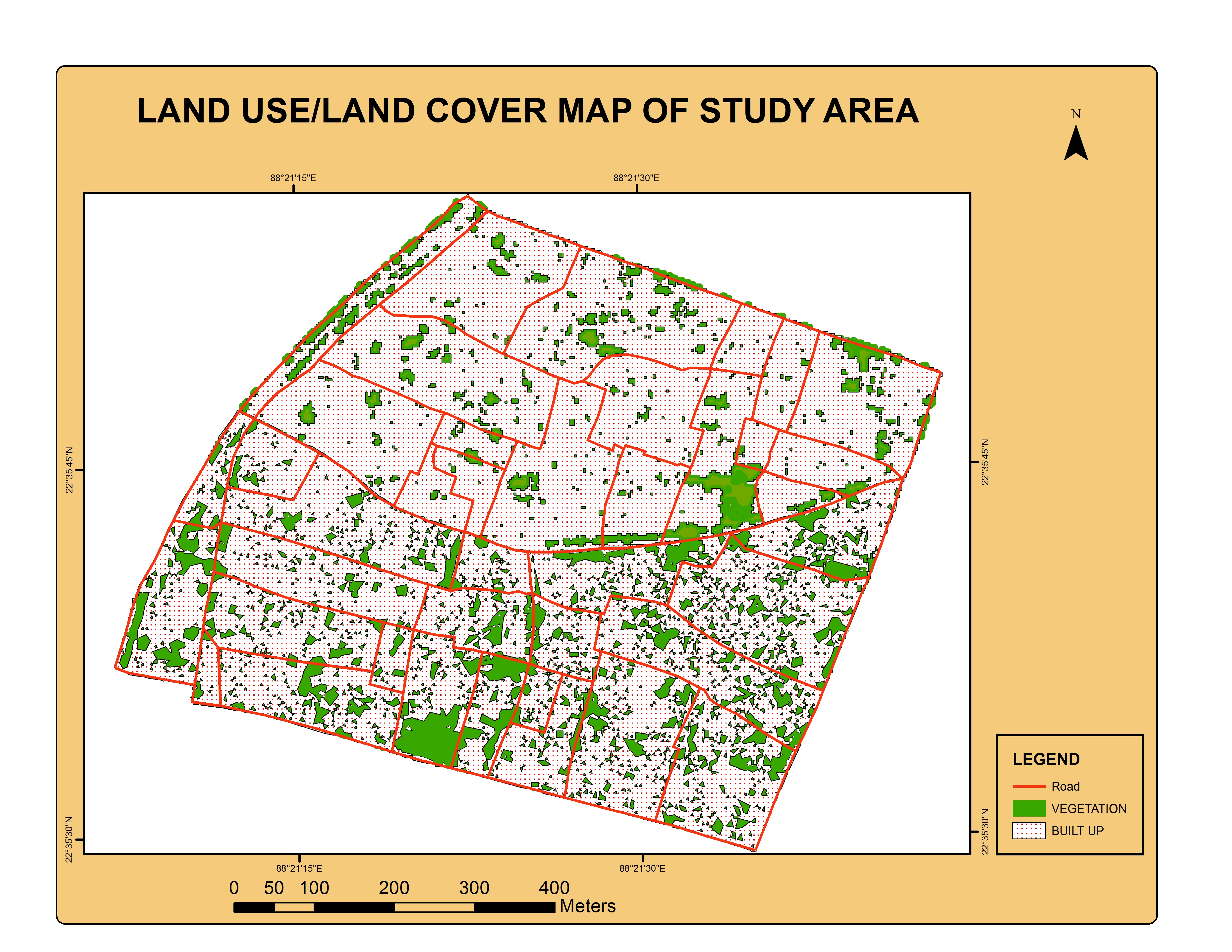
The objective of this project was to extract, classify, and map vegetation and urban features within Wards 19 and 20 of the Kolkata Municipal Corporation (KMC) Urban area. Following feature extraction, the results were subjected to statistical analysis, and a comparative assessment was carried out between the two wards to identify spatial and quantitative variations.
In this research, satellite imagery was utilized to generate a False Natural Color Composite (FNCC), which was subsequently fused with panchromatic (PAN) data to enhance spatial resolution. The fused image served as the basis for vectorizing ward boundaries and road networks. The multispectral dataset underwent two separate classification processes. In the first approach, the Normalized Difference Vegetation Index (NDVI) was derived from the multispectral data and reclassified to extract the vegetation canopy. In the second approach, the multispectral data were subjected to single-class classification to isolate and map urban features.
From the secondary data, an MS Access database was created through manual data entry. Subsequently, a geodatabase was developed to integrate the spatially extracted features with the corresponding non-spatial attributes imported from the MS Access database.
Finally, statistical analyses were performed on the extracted data, and the results were presented through charts and map layouts.
Digital Image Processing Using MATLAB: Implementation of the Gauss-Otsu Thresholding Method
![]()
National Institute of Electronics & Information Technology (Apr 2018 - Jun 2018)
This project focused on the application of advanced digital image processing techniques using MATLAB, specifically implementing a hybrid approach combining Gaussian filtering with Otsu’s thresholding method.
The objective was to enhance image segmentation accuracy by integrating noise reduction and adaptive thresholding in a cohesive framework.
The implementation was carried out in MATLAB, leveraging its built-in functions for image manipulation and matrix operations.
The algorithm was validated using a set of grayscale images with varying levels of contrast and noise. Comparative results demonstrated that the Gaussian-Otsu method outperformed the standard Otsu thresholding, particularly in preserving object boundaries and reducing false segmentation.
Web-Based Application for Showcasing GPS and DGPS Instruments Using LAMP Stack and MVC Architecture
![]()
National Institute of Electronics & Information Technology (Mar 2017 - Jun 2017)
The project aimed to design and implement a web-based application focused on cataloguing and presenting a variety of Global Positioning System (GPS) and Differential Global Positioning System (DGPS) instruments. The primary motivation was to create an interactive and informative platform for users, researchers, and field practitioners to explore detailed technical specifications, operational principles, and application domains of these geospatial instruments.
The development of the application was carried out using the LAMP stack, which comprises Linux (operating system), Apache (web server), MySQL (relational database management system), and PHP (server-side scripting language). This technology stack was selected for its open-source nature, strong community support, cross-platform compatibility, and efficiency in developing dynamic web applications.
To ensure a modular, scalable, and maintainable codebase, the Model-View-Controller (MVC) architectural pattern was adopted
The website featured sections that organized GPS and DGPS instruments based on their manufacturer, accuracy class, intended application (e.g., surveying, mapping, navigation), and mode of signal reception. Each instrument profile included high-resolution images, technical datasheets, key specifications (such as accuracy, range, and satellite compatibility), and real-world use cases.
Design and Deployment of an Interactive Webportal Using MapServer: A CGI-Based Geoportal for Geospatial Data Dissemination
![]()
Computer-Aided Design Centre, Jadavpur University, Kolkata, West Bengal, India (Aug 2016 - Dec 2016)
This project focused on the design and deployment of an _interactive web-based geoportal utilizing _MapServer, an open-source platform for publishing spatial data and interactive mapping applications to the web.
The implementation was based on the Common Gateway Interface (CGI) model, enabling efficient server-side handling of geospatial data requests and dynamic map rendering.
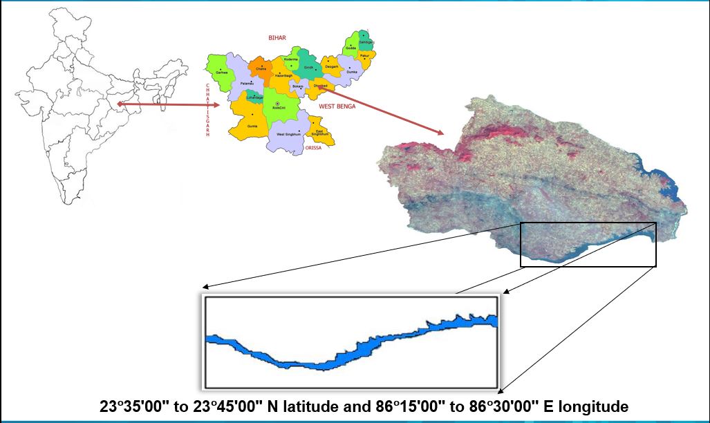
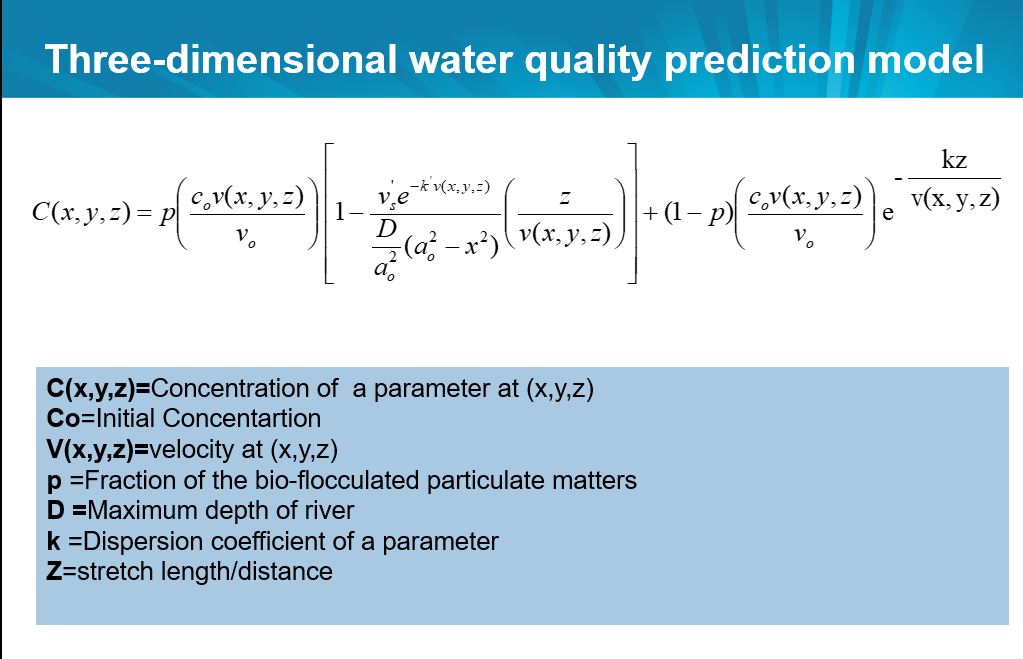
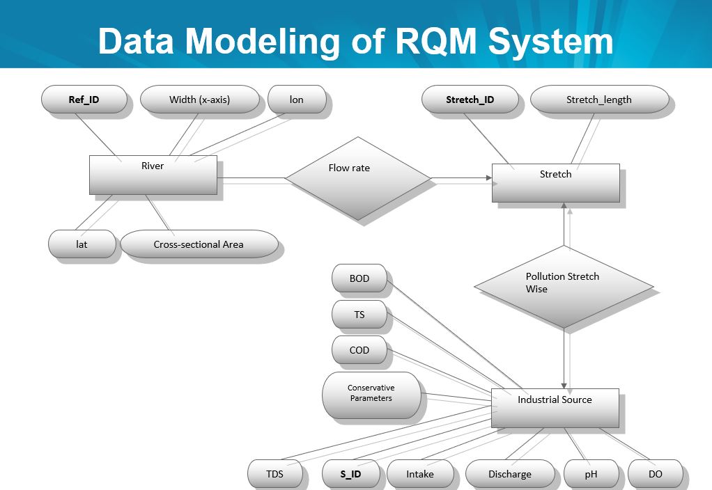
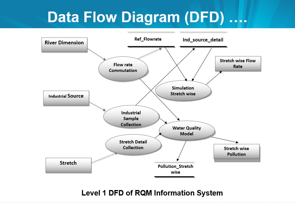
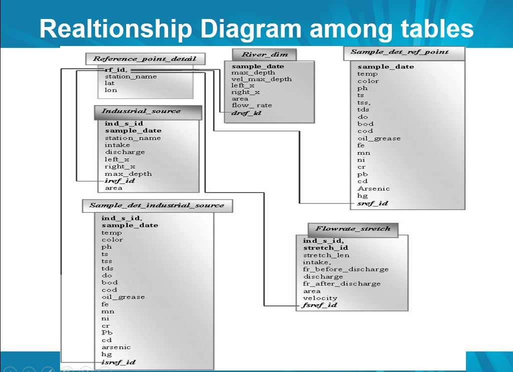
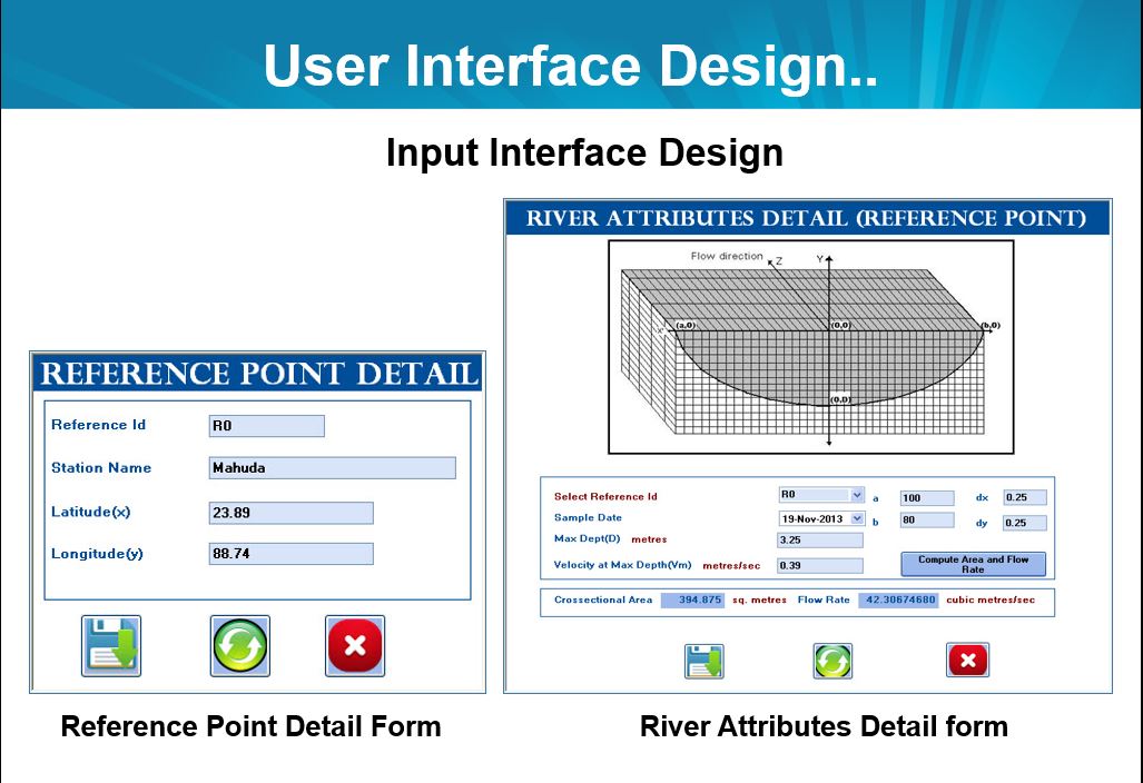
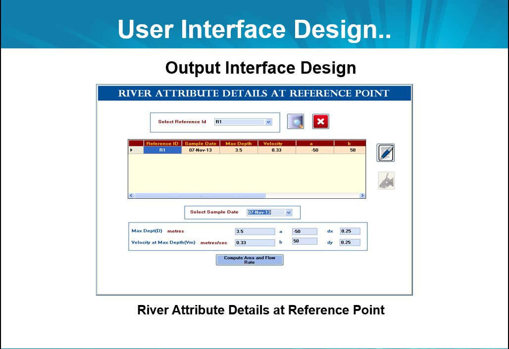
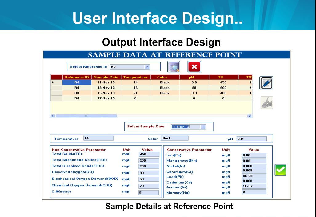
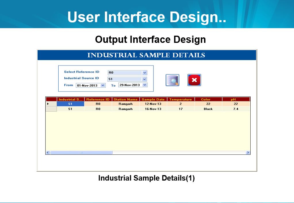
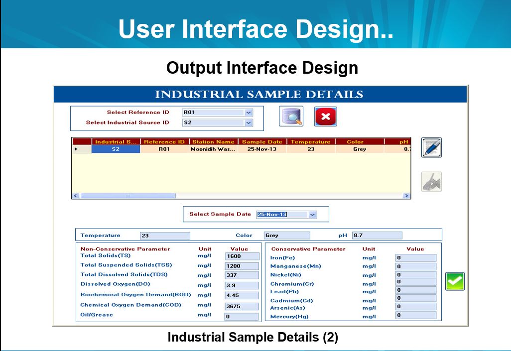
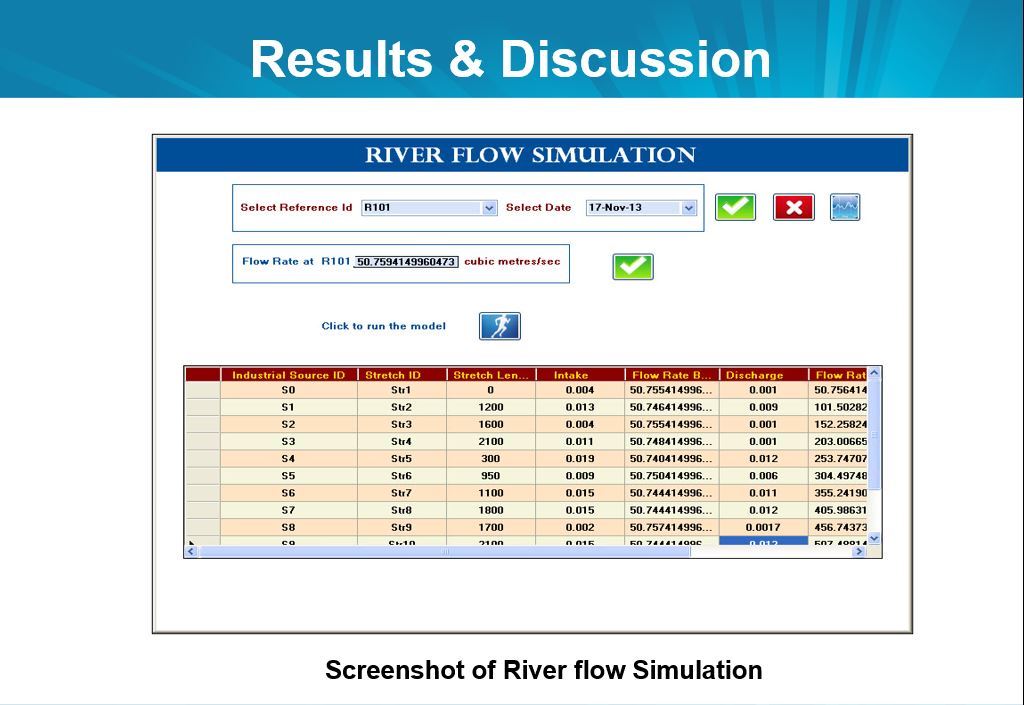
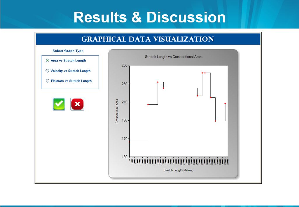
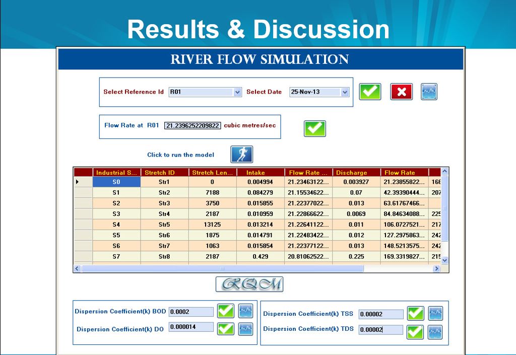
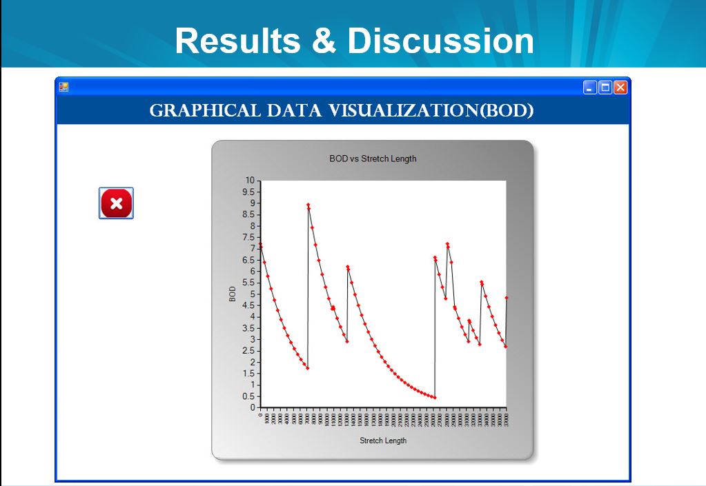
Design & Development of River Water Quality Management (RQM) Information System Using Data Visualisation Techniques for River Stretches Blending with Multi-Industrial Effluents
![]()
Department of Computer Application, Vinoba Bhave University, Hazaribagh, Jharkhand, India (Jun 2013-Feb 2014)
The River Quality Management System is an information system designed to assess the current pollution levels in a river stretch affected by multiple industrial outfalls. It facilitates the analysis of water quality data, evaluates the extent of pollution, and supports the formulation of appropriate measures to mitigate and control pollution within the targeted river segment.
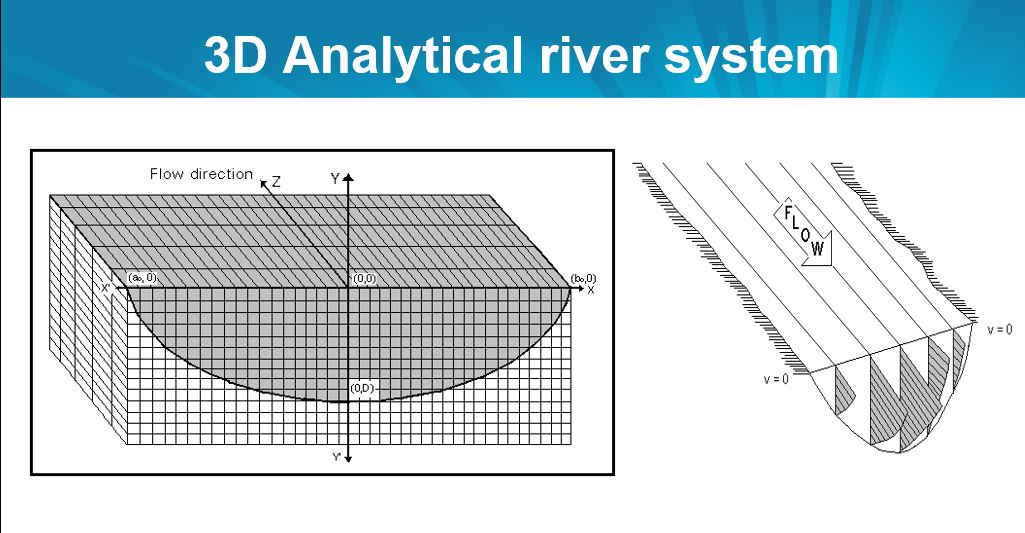
The system accounts for both conservative and non-conservative pollution parameters, calculating their concentrations at various points along the river stretch.
For this purpose, the system incorporates various mathematical models to compute velocity variations along the river stretch, flow rates, and cross-sectional areas.
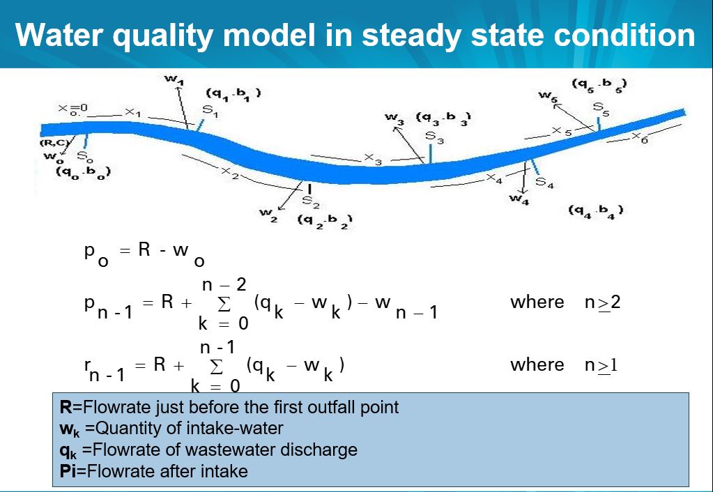
Finally, the system employs a three-dimensional water quality model to compute the concentrations of various pollutants at multiple points along the river stretch, thereby enabling the prediction of overall river water quality.
The system also incorporates data visualisation techniques to generate graphical representations, facilitating the analysis of the current water pollution scenario.
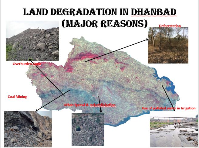
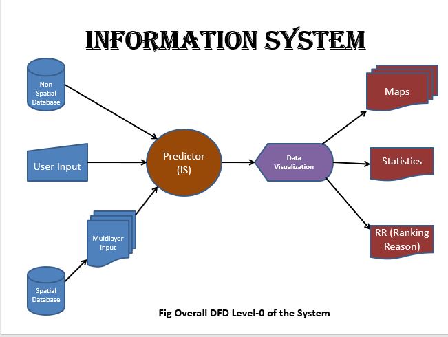
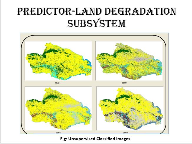
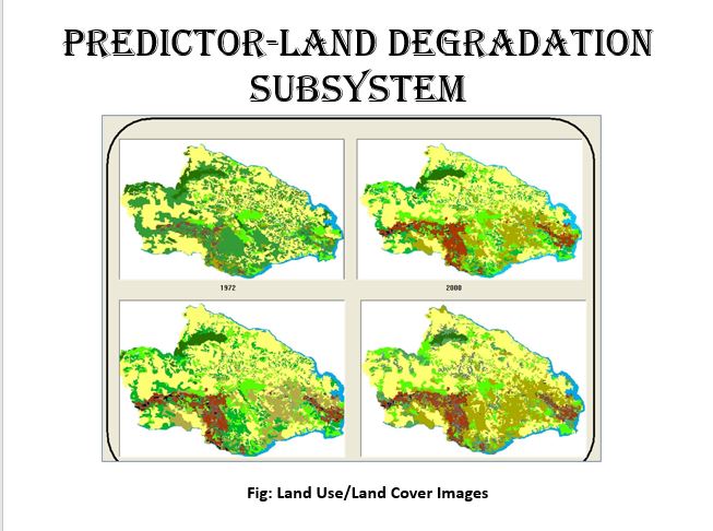
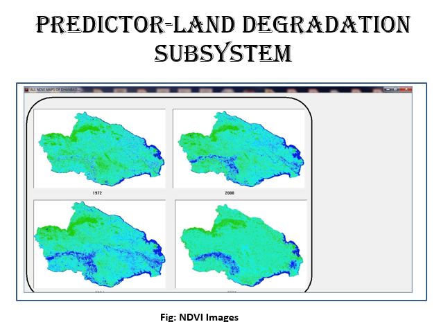
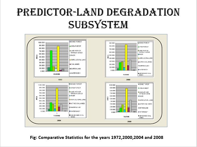
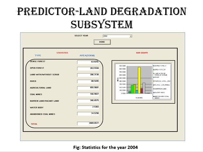
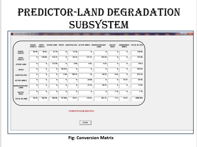
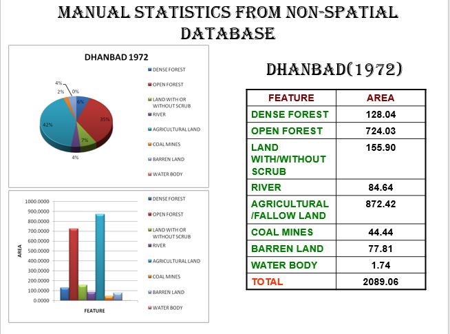
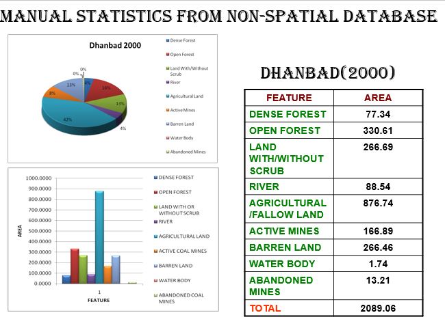
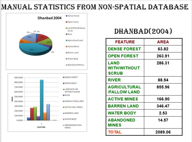
Vulnerability assessment of Dhanbad district using Remote Sensing and GIS and development of Information System (Predictor) using COM programming
![]()
Department of Remote Sensing, BIT Mesra, Ranchi, Jharkhand, India (Jan 2009-June 2009)
The primary objective of this project was to analyse multiple hazards in the Dhanbad district—namely land degradation, mine fires, air pollution, and water pollution and to prepare a vulnerability zonation map of the entire district. This map serves to identify and predict which hazard poses the greatest risk to residents. To facilitate this analysis, a software module named Predictor was developed, utilising Visual Basic as the front end and Oracle 8i as the back end.
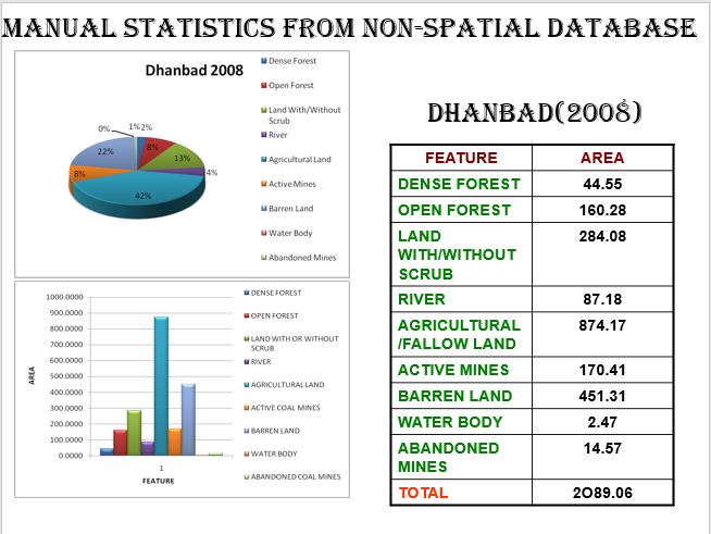
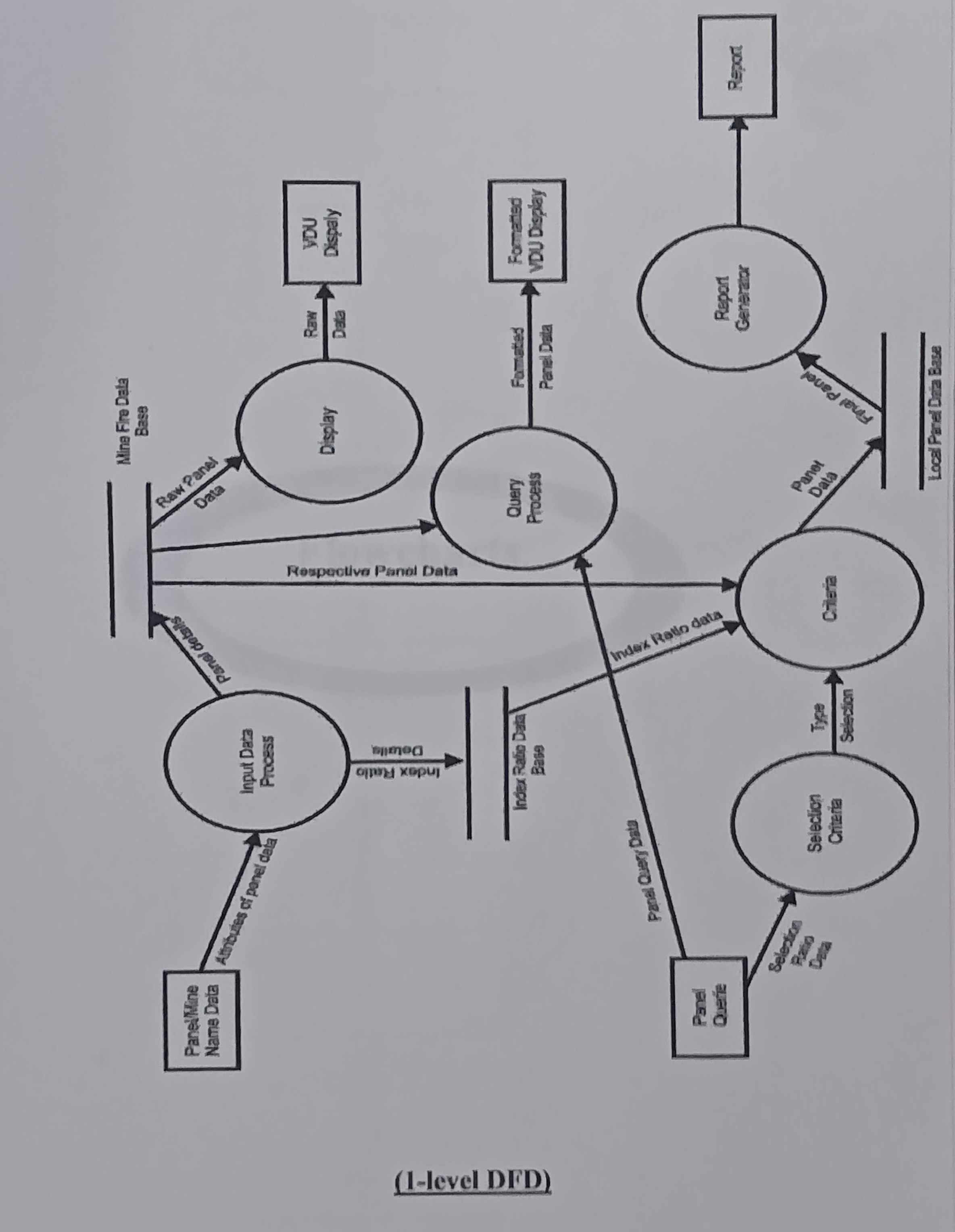
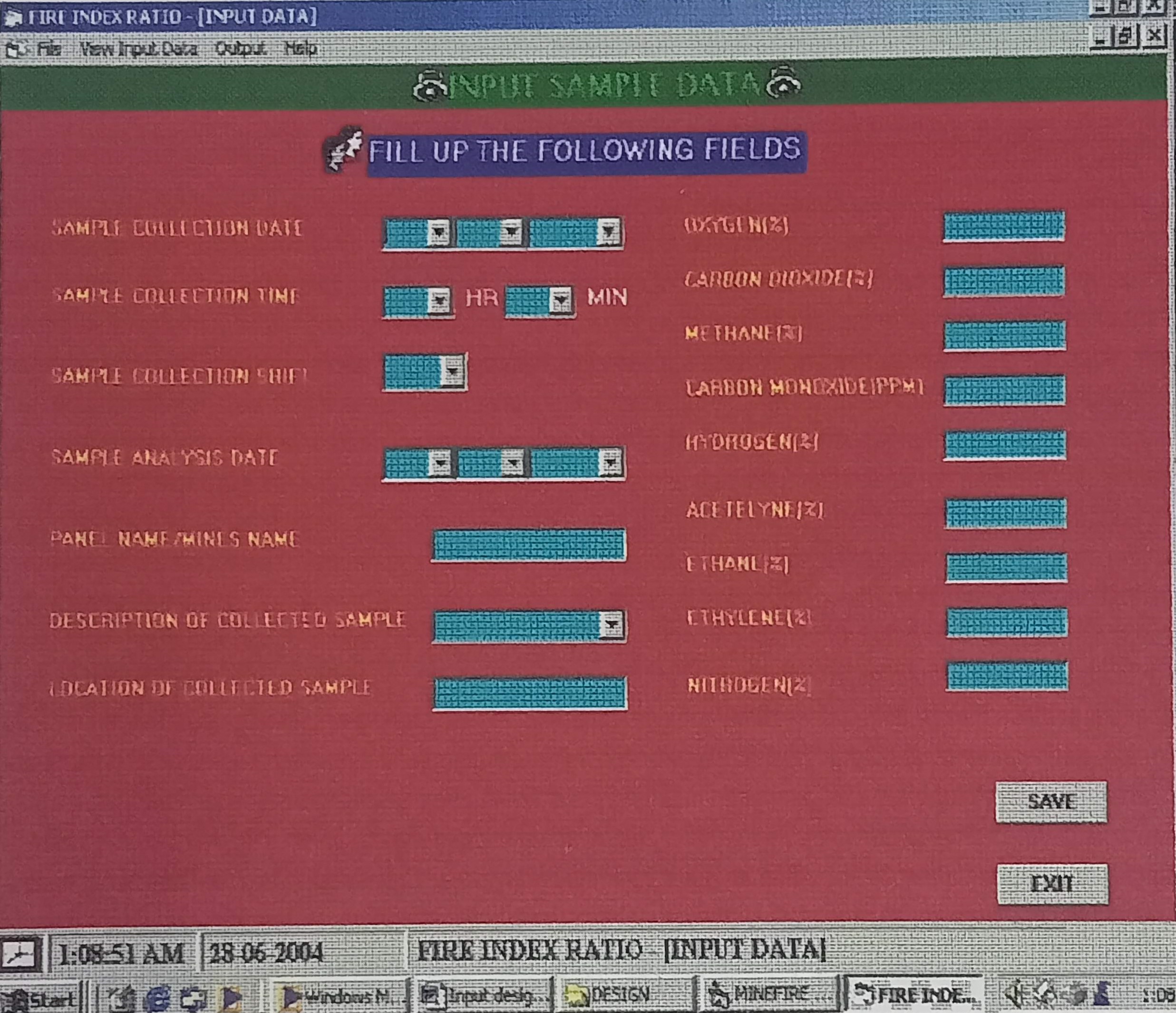
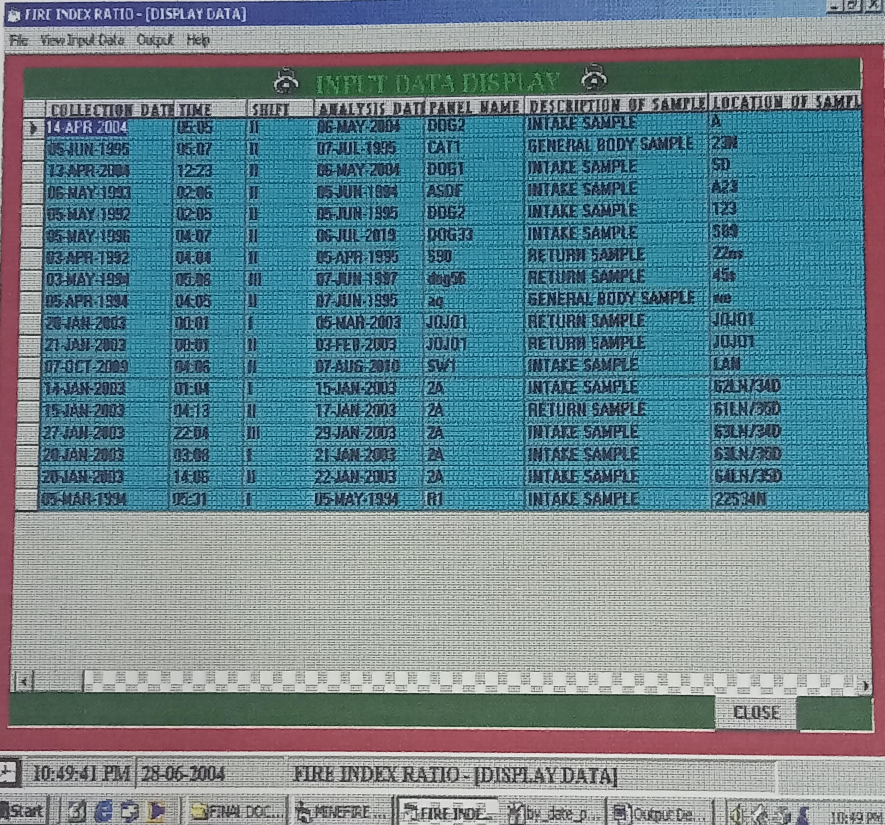
Development of Fire Index Ratio (Mine Fire) Software
![]()
CSIR-Central Institute of Mining and Fuel Research (Jan 2004-June 2004)
Coal fires are a significant environmental and industrial concern in many coal-bearing countries, including the USA, South Africa, Venezuela, China, and India. The Jharia Coalfield (JCF) in India, which holds the world’s largest reserve of prime coking coal, is particularly threatened by such fires.
During coal oxidation in sealed-off mines, various toxic and non-toxic gases are released. Monitoring of these fire gases is essential for assessing the status and intensity of the fires. To achieve this, several fire indices were calculated to evaluate the extent of the combustion. These indices were computed using Visual Basic 6.0 and stored in an Oracle 8i database. Additionally, graphical representations were generated to visualise and interpret the fire status.
Banking System-Transaction Management
![]()
Makhanlal Chaturvedi Rashtriya Patrakarita Vishwavidyalaya (Jan 2003 - May 2003)
This project is a desktop application developed using Visual Basic 6 for the front end and Microsoft Access for the back-end database. It simulates the basic functionalities of a banking system, including account creation, deposit, withdrawal, fund transfer, and transaction history.
Certifications
![]() Certificate in Python & R Programming and Application to Data Analytics from St. Xavier College, Kolkata, India, in March 2024.
Certificate in Python & R Programming and Application to Data Analytics from St. Xavier College, Kolkata, India, in March 2024.
![]() Programming ArcGIS with Python from Jadavpur University, Kolkata in Oct 2021.
Programming ArcGIS with Python from Jadavpur University, Kolkata in Oct 2021.
![]() Analysis and Simulation of Urban Growth from Remote Sensing Data from Jadavpur University, Kolkata, in March 2021.
Analysis and Simulation of Urban Growth from Remote Sensing Data from Jadavpur University, Kolkata, in March 2021.
![]() SAR Image Processing using Open Source Software from Jadavpur University, Kolkata in December 2020.
SAR Image Processing using Open Source Software from Jadavpur University, Kolkata in December 2020.
![]() Certificate Course on Machine Learning and Digital Image Processing through MATLAB from NIELIT Centre, Jadavpur Campus, Kolkata with Grade A.
Certificate Course on Machine Learning and Digital Image Processing through MATLAB from NIELIT Centre, Jadavpur Campus, Kolkata with Grade A.
![]() Certificate Course on LAMP (Linux, Apache, MySQL, and PHP) from NIELIT Centre, Jadavpur Campus, Kolkata in June 2017 for further Research work in WebGIS using open-source packages with Grade A.
Certificate Course on LAMP (Linux, Apache, MySQL, and PHP) from NIELIT Centre, Jadavpur Campus, Kolkata in June 2017 for further Research work in WebGIS using open-source packages with Grade A.
![]() Certificate Course on MATLAB from NIELIT Centre, Jadavpur Campus, Kolkata in April 2017 with Grade B+.
Certificate Course on MATLAB from NIELIT Centre, Jadavpur Campus, Kolkata in April 2017 with Grade B+.
![]() Certificate Course on WebGIS – from Concepts to Implementations from Jadavpur University, Kolkata in January 2017.
Certificate Course on WebGIS – from Concepts to Implementations from Jadavpur University, Kolkata in January 2017.
![]() Certificate Course on Object Oriented Programming Using C# from NIIT in July 2015.
Certificate Course on Object Oriented Programming Using C# from NIIT in July 2015.
🌏 Certificate Course on six-month Industrial Training Programme on Web Designing, Web Development, and Web Hosting by Techno Point Computers, Registered under the Ministry of Small Scale Industry, GOI in December 2013.
![]() Certificate Course on Remote Sensing, GIS, GPS by Indian Institute of Remote Sensing & National Remote Sensing Agency, Department of Space, Govt. of India, in EDUSAT-based training for Universities sponsored by National Natural Resource Management System (NNRMS) in December 2007
Certificate Course on Remote Sensing, GIS, GPS by Indian Institute of Remote Sensing & National Remote Sensing Agency, Department of Space, Govt. of India, in EDUSAT-based training for Universities sponsored by National Natural Resource Management System (NNRMS) in December 2007
Other Certifications
![]() ARSET - Introduction to NASA Earth Observations and Tools for Operational Wildfire Monitoring and Management in July 2025
ARSET - Introduction to NASA Earth Observations and Tools for Operational Wildfire Monitoring and Management in July 2025
![]() ARSET - Monitoring Global Terrestrial Surface Water Height using Remote Sensing in July 2025
ARSET - Monitoring Global Terrestrial Surface Water Height using Remote Sensing in July 2025
![]() ARSET - The Application of Earth Observations for Assessing Waterborne Disease Risk in May 2025
ARSET - The Application of Earth Observations for Assessing Waterborne Disease Risk in May 2025
![]() ARSET - Calculating Spectral Indices for Land and Aquatic Applications Using QGIS in April 2025
ARSET - Calculating Spectral Indices for Land and Aquatic Applications Using QGIS in April 2025
![]() ARSET - Landslide Monitoring and Risk Assessment Using NASA Earth System Data in April 2025
ARSET - Landslide Monitoring and Risk Assessment Using NASA Earth System Data in April 2025
![]() ARSET - Earth Observations of Blue Carbon Ecosystems in February 2025
ARSET - Earth Observations of Blue Carbon Ecosystems in February 2025
![]() ARSET - An Introduction to Synthetic Aperture Radar (SAR) and Its Applications in January 2025
ARSET - An Introduction to Synthetic Aperture Radar (SAR) and Its Applications in January 2025
![]() ARSET - Methane Observations for Large Emission Event Detection and Monitoring in January 2025
ARSET - Methane Observations for Large Emission Event Detection and Monitoring in January 2025
![]() ARSET - Introduction to Plankton, Aerosol, Cloud, Ocean Ecosystem (PACE) Hyperspectral Observations for Water Quality Monitoring in December 2024
ARSET - Introduction to Plankton, Aerosol, Cloud, Ocean Ecosystem (PACE) Hyperspectral Observations for Water Quality Monitoring in December 2024
![]() ARSET - Drought Monitoring, Prediction, and Projection using NASA Earth System Data in October 2024
ARSET - Drought Monitoring, Prediction, and Projection using NASA Earth System Data in October 2024
![]() ARSET - Invasive Species Monitoring with Remote Sensing in October 2024
ARSET - Invasive Species Monitoring with Remote Sensing in October 2024
![]() ARSET - Atmospheric Composition Ground Networks Supporting Air Quality and Climate Applications in October 2024
ARSET - Atmospheric Composition Ground Networks Supporting Air Quality and Climate Applications in October 2024
![]() ARSET - Applications of Carbon Dioxide Measurements for Climate-Related Studies in September 2024
ARSET - Applications of Carbon Dioxide Measurements for Climate-Related Studies in September 2024
![]() NASA Open Science in September 2024
NASA Open Science in September 2024
![]() NASA’s Open Science 101 Curriculum in September 2024.
NASA’s Open Science 101 Curriculum in September 2024.
![]() Regression Analysis: Performing Random Forest Regression Using ArcGIS Pro from ESRI 2024
Regression Analysis: Performing Random Forest Regression Using ArcGIS Pro from ESRI 2024
![]() ARSET - Introduction to Lightning Observations and Applications in May 2024
ARSET - Introduction to Lightning Observations and Applications in May 2024
![]() Cartography from ESRI in May 2024
Cartography from ESRI in May 2024
![]() ARSET - Overview of SeaDAS 8.4.1 for the Processing, Analysis, and Visualization of Optical Remote Sensing Data for Water Quality Monitoring in April 2024.
ARSET - Overview of SeaDAS 8.4.1 for the Processing, Analysis, and Visualization of Optical Remote Sensing Data for Water Quality Monitoring in April 2024.
![]() ArcGIS Pro Basics from ESRI in March 2024
ArcGIS Pro Basics from ESRI in March 2024
![]() Transform AEC Projects with GIS and BIM from ESRI in March 2024.
Transform AEC Projects with GIS and BIM from ESRI in March 2024.
![]() SDG Indicator 2.4.1 Sustainable Agriculture from FAO in Feb 2024.
SDG Indicator 2.4.1 Sustainable Agriculture from FAO in Feb 2024.
![]() ARSET - Satellite Data for Air Quality, Environmental Justice and Equity Applications on Nov 2023.
ARSET - Satellite Data for Air Quality, Environmental Justice and Equity Applications on Nov 2023.
![]() ARSET - Monitoring Water Quality of Inland Lakes using Remote Sensing in Oct 2023.
ARSET - Monitoring Water Quality of Inland Lakes using Remote Sensing in Oct 2023.
![]() ARSET - Assessing the Impacts of Fires on Watershed Health in Sept 2023.
ARSET - Assessing the Impacts of Fires on Watershed Health in Sept 2023.
![]() AI for India 2.0, IITM Research Park, issued Aug 2023.
AI for India 2.0, IITM Research Park, issued Aug 2023.
![]() ARSET - Fundamentals of Machine Learning for Earth Science, issued Aug 2023.
ARSET - Fundamentals of Machine Learning for Earth Science, issued Aug 2023.
![]() Python, IITM Research Park, issued Aug 2023.
Python, IITM Research Park, issued Aug 2023.
![]() ARSET - Crop Mapping using Synthetic Aperture Radar (SAR) and Optical Remote Sensing in July 2023.
ARSET - Crop Mapping using Synthetic Aperture Radar (SAR) and Optical Remote Sensing in July 2023.
![]() ARSET- Biodiversity Applications for Airborne Imaging Systems in June 2023.
ARSET- Biodiversity Applications for Airborne Imaging Systems in June 2023.
![]() ARSET - Connecting Citizen Science with Remote Sensing in March 2023.
ARSET - Connecting Citizen Science with Remote Sensing in March 2023.
![]() ARSET - Disaster Assessment Using Synthetic Aperture Radar from NASA (National Aeronautics and Space Administration) in January 2023.
ARSET - Disaster Assessment Using Synthetic Aperture Radar from NASA (National Aeronautics and Space Administration) in January 2023.
![]() GIS for Climate Action from ESRI in Dec 2023.
GIS for Climate Action from ESRI in Dec 2023.
![]() ARSET - Earth Observations Toolkit for Sustainable Cities and Human Settlements from NASA (National Aeronautics and Space Administration) in April 2022.
ARSET - Earth Observations Toolkit for Sustainable Cities and Human Settlements from NASA (National Aeronautics and Space Administration) in April 2022.
![]() ARSET - Using Earth Observations for Pre- and Post-Fire Monitoring from NASA (National Aeronautics and Space Administration) in March 2022.
ARSET - Using Earth Observations for Pre- and Post-Fire Monitoring from NASA (National Aeronautics and Space Administration) in March 2022.
![]() ARSET - Monitoring Coastal and Estuarine Water Quality Using Remote Sensing and In Situ Data from NASA (National Aeronautics and Space Administration) in February 2022.
ARSET - Monitoring Coastal and Estuarine Water Quality Using Remote Sensing and In Situ Data from NASA (National Aeronautics and Space Administration) in February 2022.
![]() ARSET - Agricultural Crop Classification with Synthetic Aperture Radar and Optical Remote Sensing from NASA (National Aeronautics and Space Administration) in December 2021.
ARSET - Agricultural Crop Classification with Synthetic Aperture Radar and Optical Remote Sensing from NASA (National Aeronautics and Space Administration) in December 2021.
![]() ARSET - Monitoring Coastal and Estuarine Water Quality: Transitioning from MODIS to VIIRS from NASA (National Aeronautics and Space Administration) in December 2021.
ARSET - Monitoring Coastal and Estuarine Water Quality: Transitioning from MODIS to VIIRS from NASA (National Aeronautics and Space Administration) in December 2021.
![]() Spatial Data Science: The New Frontier in Analytics from ESRI in December 2021
Spatial Data Science: The New Frontier in Analytics from ESRI in December 2021
![]() Going Places with Spatial Analysis from ESRI in November 2021
Going Places with Spatial Analysis from ESRI in November 2021
![]() ARSET - Satellite Observations for Analysing Natural Hazards on Small Island Nations from NASA (National Aeronautics and Space Administration) in October 2021.
ARSET - Satellite Observations for Analysing Natural Hazards on Small Island Nations from NASA (National Aeronautics and Space Administration) in October 2021.
![]() MOOC Imagery in Action from ESRI in September 2021
MOOC Imagery in Action from ESRI in September 2021
Experience
Software Engineer

HCLTech, Plot no.5, Sector 12, MIHAN SEZ, Nagpur, Telhara, Maharashtra 441108, India (Dec 2021 - July 2023)
Client: Franklin Templetion
Faculty and Research Associate

A-145. Sector - 63. Noida, U.P. 201301, India (May 2010 - March 2012)
Project Trainee
![]()
CSIR-Central Institute of Mining and Fuel Research (Jan 2004 - Jun 2004)
Publications
Contact Information
![]()