Gaurav Chakrabarty
Repository of my web page
Band Ratioing Defined
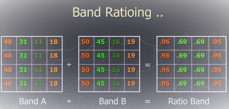
Band ratioing in Remote Sensing is used to display spectral variations. Spectral band ratioing enhances the desired compositional information while suppressing other types of information, such as the terrain slope and grain-size differences.
Band ratioing is a technique in which DN values in one spectral band is divided from the corresponding values in another band. The resultant image is commonly known as a ratioed image.
Different Indices
Normalized Difference Vegetation Index (NDVI) :
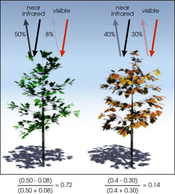
The NDVI is a band ratioing involving visible red and near-infrared bands of satellite images and determines the vegetation cover over a particular area. It is a simple numerical indicator used to assess whether the target being observed contains live green vegetation.
NDVI = (NIR - Red) / (NIR + Red)
In Landsat 4-7, NDVI = (Band 4 – Band 3) / (Band 4 + Band 3).
In Landsat 8-9, NDVI = (Band 5 – Band 4) / (Band 5 + Band 4).
The results span from -1.0 to +1.0, where
-1.0 to 0: Indicates Water bodies, clouds, snow, or non-living structures like concrete and roads.
0 to 0.2: Indicates Bare soil, rocks, or sand with little to no vegetation.
0.2 to 0.4: Indicates Sparse or stressed vegetation like dry grasslands and shrubs.
0.6 to 1.0: Indicates Dense, robust vegetation like temperate crops, thick and healthy forests, and tropical rainforests.
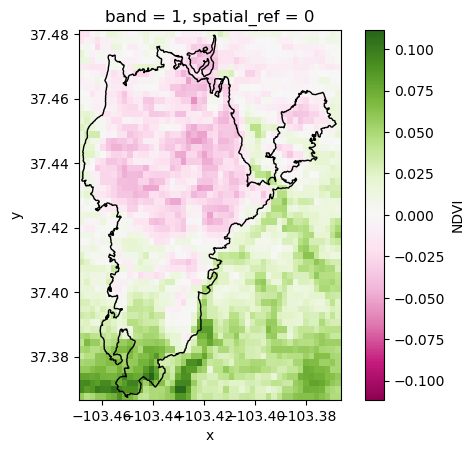
Figure: NDVI Map of Cherry Canyon Park, California, USA.
Normalized Difference Water Index (NDWI) :
NDWI has been computed using the specified bands of the LISS III images (GREEN and NIR).
It is a metric used to detect and monitor water bodies or measure liquid water absorption in vegetation.
To monitor changes related to water content in water bodies, using green and NIR wavelengths, defined by McFeeters (1996) following ratioing is used:
NDWI = (Green - NIR) / (Green + NIR)
To monitor changes in the water content of leaves, using near-infrared (NIR) and short-wave infrared (SWIR) wavelengths, as proposed by Gao (1996) following ratioing is used:
NDWI = (NIR - SWIR) / (NIR + SWIR)
NDWI values likely range between −1 and 1
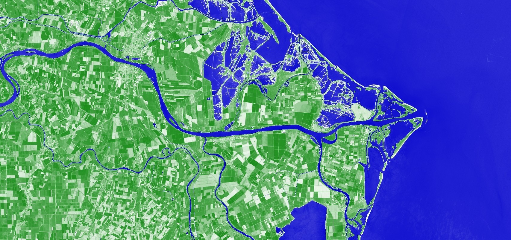
Figure: NDWI image of Italy. Acquired on 2020-08-01
Source: https://custom-scripts.sentinel-hub.com/custom-scripts/sentinel-2/ndwi/
Normalized Difference Built-up Index (NDBI) :
NDBI targets built-up areas to recognize maximum reflectance in the shortwave infrared (SWIR) wavelengths that are coming out. Like the previous two indices NDVI & NDWI, this index is also based on band ratioing and provides inputs for modern urban planning.
NDBI uses the NIR and SWIR bands to emphasize manufactured built-up areas, and it uses the following ratioing:
NDBI = (SWIR - NIR) / (SWIR + NIR)
The values range from -1 to +1.
Positive values signify built-up structures, whereas negative values represent water, soil, or vegetation.
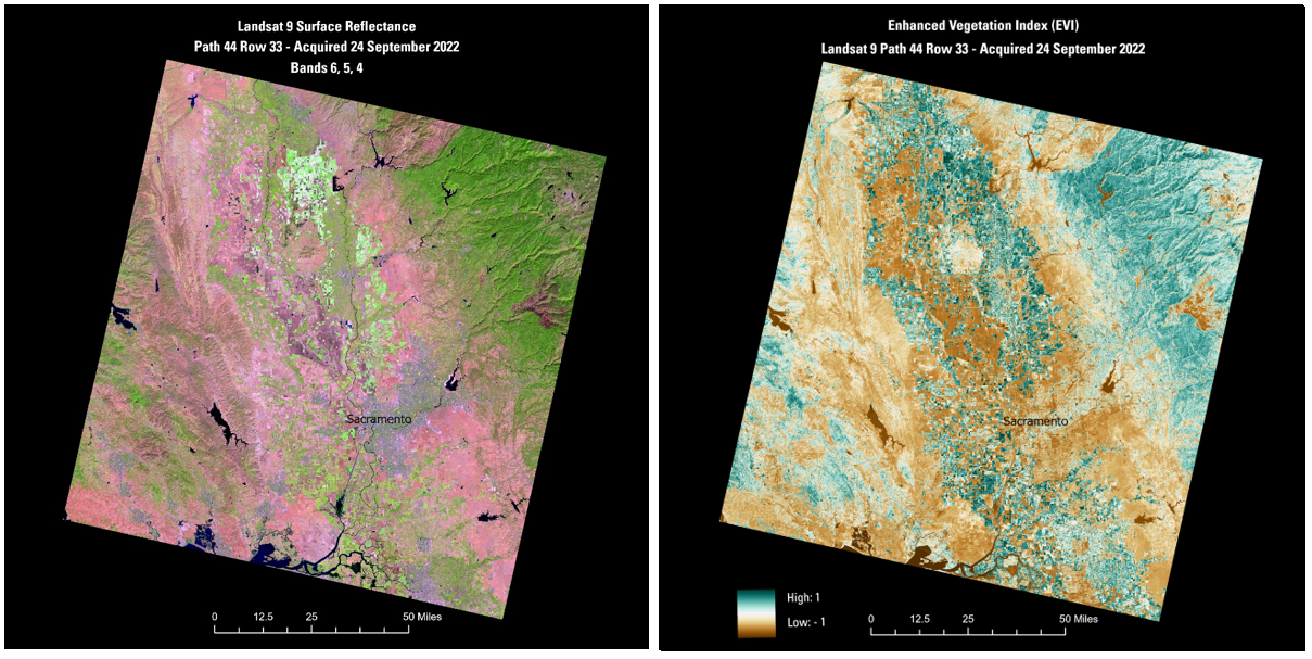
Enhanced Vegetation Index (EVI) :
EVI is similar to NDVI and can be used to quantify vegetation greenness.
Additionally, EVI corrects for some atmospheric conditions and canopy background noise and is more sensitive in areas with dense vegetation.
It incorporates an “L” value to adjust for canopy background, “C” values as coefficients for atmospheric resistance, and values from the blue band (B). These enhancements allow for index calculation as a ratio between the R and NIR values, while reducing the background noise, atmospheric noise, and saturation in most cases.
EVI is given by the following ratio (Landsat Missions, USGS):
EVI = G * ((NIR - R) / (NIR + C1 * R – C2 * B + L))
In Landsat 4-7, EVI = 2.5 * ((Band 4 – Band 3) / (Band 4 + 6 * Band 3 – 7.5 * Band 1 + 1)).
In Landsat 8-9, EVI = 2.5 * ((Band 5 – Band 4) / (Band 5 + 6 * Band 4 – 7.5 * Band 2 + 1)).
The value range typically spans from -1 to 1, where healthy, dense vegetation registers approximately between 0.20 and 0.80.
Source: https://www.usgs.gov/landsat-missions/landsat-enhanced-vegetation-index
Normalized Burn Ratio (NBR) :
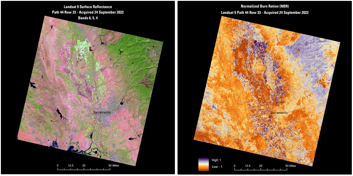
NBR was designed to highlight burned areas and estimate fire severity.
It uses near-infrared (NIR) and shortwave-infrared (SWIR) wavelengths.
NBR = (NIR - SWIR) / (NIR + SWIR)
Pre-fire, healthy vegetation has very high near-infrared reflectance and low reflectance in the shortwave infrared portion of the spectrum.
Recently burned areas, on the other hand, have relatively low reflectance in the near-infrared and high reflectance in the shortwave infrared band.
A high NBR value generally indicates healthy vegetation, while a low value indicates bare ground and recently burned areas.
Source: https://gsp.humboldt.edu/olm/Courses/GSP_216/lessons/Spectral-Enhancements/NBR.html
Source: https://www.usgs.gov/landsat-missions/landsat-normalized-burn-ratio
Soil Adjusted Vegetation Index (SAVI) :
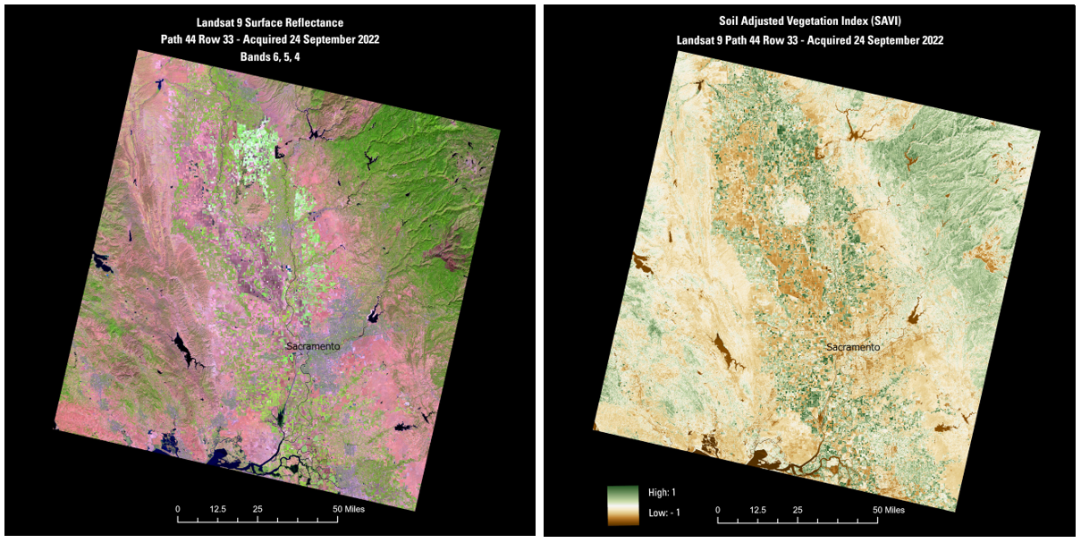
SAVI is a remote sensing metric used to measure plant health while minimizing background soil brightness interference.
It is similar to NDVI but is used in areas where vegetative cover is low (< 40%).
When a significant amount of the soil surface is exposed, the soil reflectance can influence the NDVI values.
Light reflected from the soil can have a significant effect on NDVI values (changing the values by up to 20%)
SAVI is given by the following ratio:
SAVI = [(NIR - Red) / (NIR + Red + L)] * (1 + L)
“L” is a correction factor which ranges from 0 for very high vegetation cover to 1 for very low vegetation cover.
An “L” value of 0.5 is typically used for intermediate vegetation cover.
When “L” is equal to zero SAVI becomes the same equation as NDVI.
Source: https://www.usgs.gov/media/images/landsat-surface-reflectance-and-soil-adjusted-vegetation-index
Normalized Difference Snow Index (NDSI) :
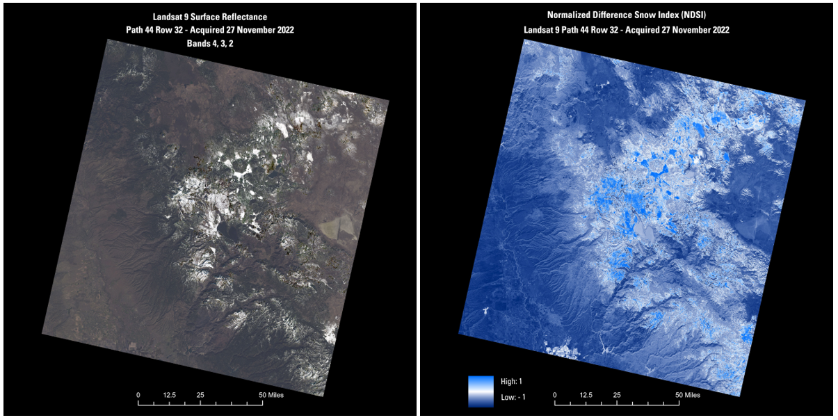
NDSI is used to identify snow cover and is often used for hydrological forecasting.
It is given by the following ratio:
NSDI = (Visible - SWIR) / (Visible + SWIR)
The NDSI uses the TM and ETM+ Bands 2 and 5, whereas for OLI the algorithm uses Bands 3 and 6:
NSDI = (G – SWIR1) / (G + SWIR1)
In Landsat 4-7, NDSI = (Band 2 – Band 5) / (Band 2 + Band 5)
In Landsat 8-9, NDSI = (Band 3 – Band 6) / (Band 3 + Band 6)
Source: https://www.usgs.gov/landsat-missions/normalized-difference-snow-index
In the visible portion of the spectrum snow cover reflects highly and appears just as bright as clouds.
It is therefore visually difficult to distinguish from cloud cover.
However, in the shortwave infrared portion of the spectrum, snow reflects very little; this allows for discrimination between snow cover and clouds. Higher NDSI values ( > 0.4) typically indicate the presence of snow, although the threshold may vary depending on the imagery and type of snow or ice.